Sunshine Islands Bus Simulator map and zones
Sunshine Islands has 10 islands across 8 zones: land sits in Zones 1, 4, 6, 7 and 8, while Zones 2, 3 and 5 are open water crossed by the strategic roads.
Sunshine Islands is 10 islands divided into 8 zones. Zones 1, 4, 6, 7 and 8 hold land; Zones 2, 3 and 5 are open water that the inter-zone roads simply cross. Learn which zone you are standing in and the route numbers start explaining themselves.
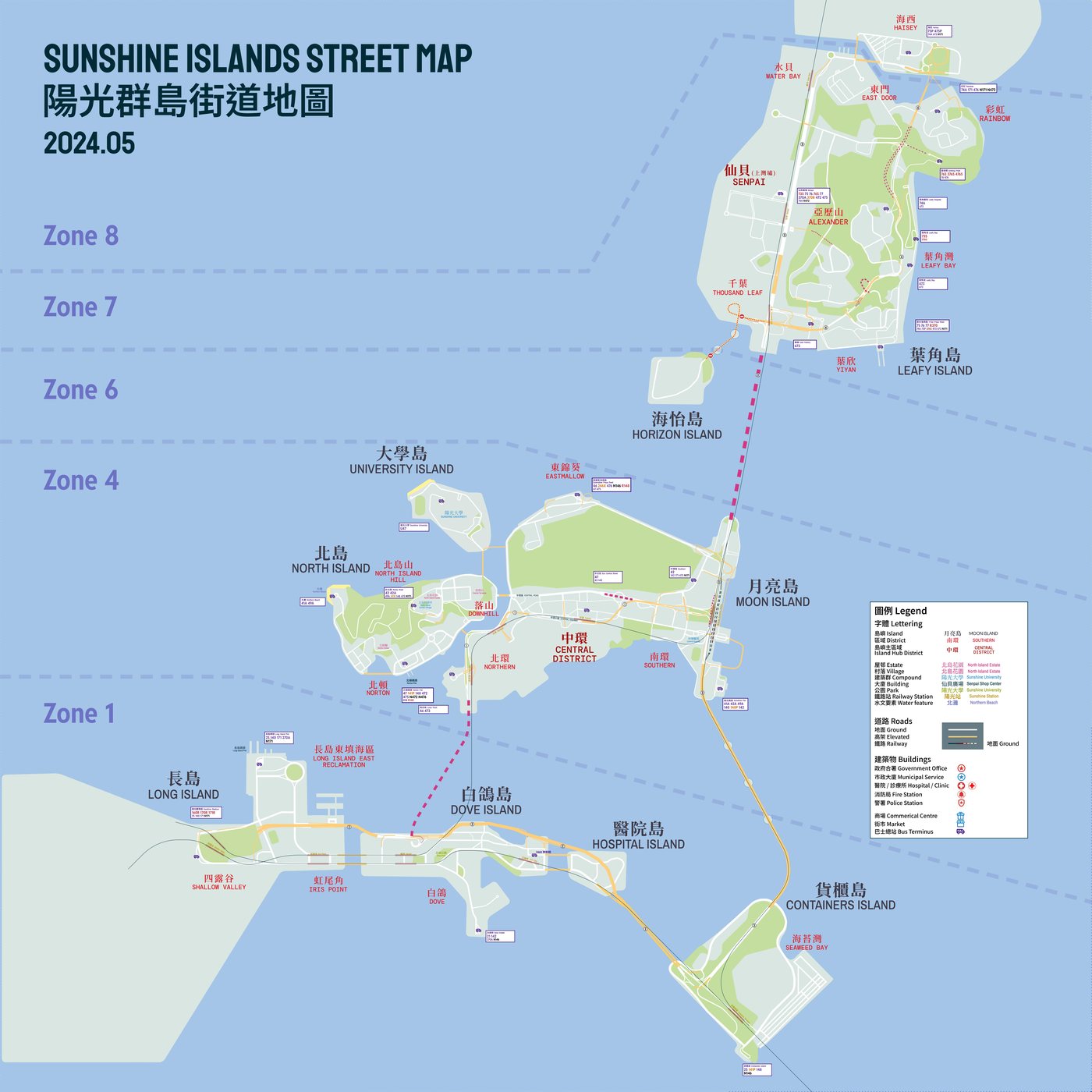
Zones and their islands
| Zone | Islands | Position | Notes |
|---|---|---|---|
| Zone 1 | Long Island, Dove Island, Hospital Island, Container's Island | West side | Reached from the centre over the Central-Western Bridge or through the Western Harbour Tunnel |
| Zone 2, 3, 5 | None — open water | Between the land zones | Only the strategic roads and bridges pass through |
| Zone 4 | Moon Island, North Island, University Island | Centre | The oldest area, opened November 2017; the main hub |
| Zone 6 | Horizon Island | North-east | Served mainly by Horizon |
| Zone 7 | Leafy Island | East | Senpai, Leafy Bay, Rainbow and YiYan corridors |
| Zone 8 | Haisey Island | South-east of Leafy Island | Added 6 February 2021 with the East Door update; still thin on transport links |
Zone 4: where almost everyone starts
Zone 4 is the centre of the map and holds three islands:
- Moon Island — the main island and the first one built. Two districts, Eastmallow and Central, split by mountains. Northern Interchange was the original spawn; the main bus spawn today is at Sunshine Pier. Landmarks include Sun Central Street, Sunshine Station, Southern Cultural District and Central Hospital. The wiki puts its population at around 250,000.
- North Island — directly north of Central, second largest island in Zone 4, around 140,000 inhabitants. Norton is the built-up district, Northern Beach the commercial strip, and V2.0 added Rocky Road terminus with a school village. The hills hold several schools, which is why demand there spikes during school hours.
- University Island — the campus island, tied to university route U47.
The zone also has the oldest, narrowest and messiest road network in the game, which is worth knowing before you take a tight inner-zone route on your first day.
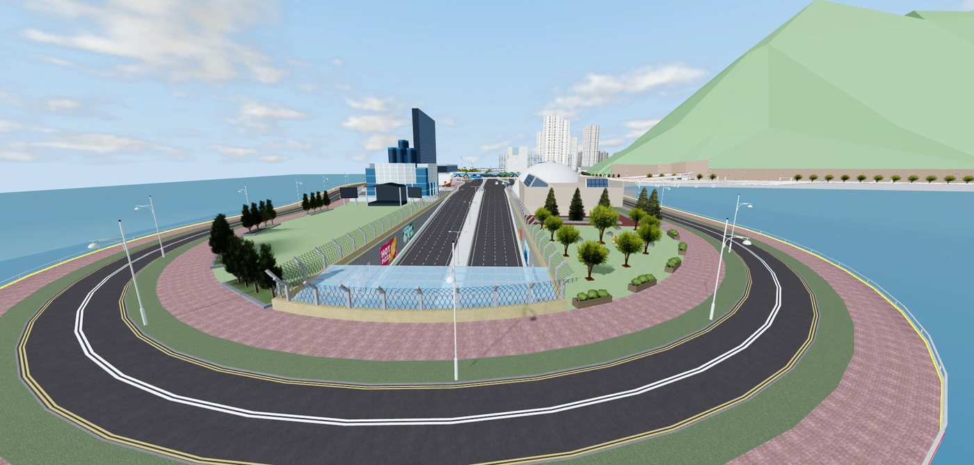
The strategic road system
Four numbered strategic roads tie the archipelago together. They are mostly multi-lane, limited-access, and posted at 70 km/h or above, with traffic lights on only a few sections.
| Route | Road |
|---|---|
| Strategic Route 1 | Central Highway, Western Harbour Tunnel |
| Strategic Route 2 | Cross-Island Highway — Long Island East Highway, Dove Island Bypass, Desire Bridge, Container's Island Highway |
| Strategic Route 3 | Axis Road, Leafy-Central Tunnel, Southern Central Road, Central-Western Bridge |
| Strategic Route 4 | Senpai Bypass, Leafy Road, East Door Tunnel, South Bay Highway |
Two tunnels and the main bridges carry you between zones: the Western Harbour Tunnel and Leafy-Central Tunnel, plus the Central-Western Bridge and Desire Bridge. Desire Bridge is the weather-sensitive one — strong winds close it to buses and push services onto the Y-pattern diversions.
Main termini worth learning first
| Terminus | Zone | Why it matters |
|---|---|---|
| Sunshine Pier | 4 | Main bus spawn on Moon Island |
| Northern Interchange | 4 | The original V1 spawn point and a major bus-to-bus interchange |
| Norton Town Center | 4 | The rebuilt Norton district hub, added around the V2.0 scenery update |
| Rocky Road | 4 | New V2.0 terminus with its school village |
| Southern Central | 4 | Sunshine Pier expansion and Southern Cultural District, June 2024 |
| Senpai Shopping Center | 7 | The Zone 7 anchor, also the start of the Urban Odyssey race route |
| Rainbow Bus Terminus | 7 | Rainbow and East Door corridors (route 75) |
| Horizon Depot | 6 | Horizon's depot on Horizon Island |
| Container's Island | 1 | Western industrial end of the network |
Finding your way around the map
The official Sunshine Islands site publishes a street map and a timetable page. The community wiki runs an interactive per-zone map index and a full 3000-pixel network map, which is the version reproduced above — open it full size, then zoom, rather than squinting at a thumbnail.
Practical navigation tips
- Read the zone first, then the road. If your route number starts with the zone you are in, you will not cross water.
- Watch the bridge and tunnel names on signs. Central-Western Bridge and Western Harbour Tunnel are different crossings with different destinations, and they decide whether you are on a 1Bx, 2Bx or 3Bx service.
- School hours change demand. North Island Hill and the Norton schools push passenger numbers up in session hours.
- Typhoon days rewrite the map. Under signal no. 8 or when Desire Bridge closes, Y-prefix and Y-suffix routes replace the normal pattern.